Ireland Land Divisions
A basic knowledge of Ireland land divisions can be helpful in making progress with family history research on the island. This page is a brief overview of how the country was/is divided for administration purposes.
Country
The whole of the island of Ireland was a part of the United Kingdom between 1801 and 1922. Prior to 1801, Ireland had been a British colony since the 16th century. For more on the UK, see: What’s the Difference between the UK, Britain and England?
In 1922, the island was partitioned with Northern Ireland remaining in the UK and the rest eventually becoming an independent republic.
Northern Ireland
After Irish partition in 1922, the six counties of Antrim, Down, Armagh, Derry (or Londonderry), Tyrone and Fermanagh remained as part of the United Kingdom as Northern Ireland.
The Republic of Ireland
Following the 1922 partition the bulk of the country, the remaining 26 counties, became the Irish Free State, and from 1937, the Republic of Ireland or Eire.
See below for a list of counties by province in the Republic.
Provinces
Ireland as a whole is divided into four provinces:
Ulster, Leinster, Munster and Connaught (or Connacht). Provinces have mostly fallen out of use since partition. Provinces were subdivided into counties.
Counties
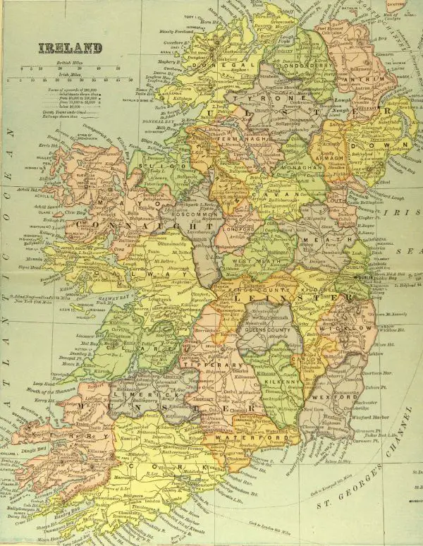
1894 Map of Ireland
There are 32 historic counties in the whole of Ireland. As mentioned above, 6 counties remained in the UK after partition. The counties by province are:
Ulster
These Ulster counties became Northern Ireland and remained in the United Kingdom following partition in 1922.
- Antrim
- Down
- Armagh
- Derry (or Londonderry)
- Tyrone
- Fermanagh
The remaining 3 counties of Ulster became part of the Republic of Ireland after 1922:
- Donegal
- Monaghan
- Cavan
All the counties in the remaining three provinces became part of the Republic of Ireland.
Leinster
- Longford
- Westmeath
- Meath
- Louth
- Offaly
- Kildare
- Dublin
- Wicklow
- Laois
- Kilkenny
- Carlow
- Wicklow
Munster
- Clare
- Tipperary
- Limerick
- Kerry
- Cork
- Waterford
Connaught (or Connacht)
- Leitrim
- Sligo
- Roscommon
- Mayo
- Galway
Counties were subdivided into baronies.
Baronies
There were over 300 baronies in Ireland. To find the baronies in a particular county, you can use Shane Wilson’s Townland Explorer. Clicking on a barony will give you a list of its townlands.
Baronies were subdivided into townlands.
Baronies are no longer in use.
Townlands
Townlands are probably the most important of the land divisions. A townland is often the place a person would identify with, especially in rural communities. It is also recorded on many documents, so knowing the townland of an ancestor is usually crucial, especially if that person had a common name.
There are over 64,000 townlands in Ireland.
To find a townland, you can use Shane Wilson’s Townland Index and Database – 1851.
Hundreds
A few of the larger townlands were further sub-divided into hundreds, although these were rarely recorded on documents.
Note: a hundred in Ireland has a different meaning to one in England. A hundred in England was more like an Irish barony, i.e., a sub-division of a county.
Other Land Divisions
Counties and baronies could also be divided into other land divisions and these may appear on historical documents.
Civil Parishes
There are over 2500 civil parishes in Ireland.
You can use the Townland Explorer to find civil parishes.
Poor Law Union
Use the Townland Explorer to also find Poor Law Unions.
Registration Districts
There were over 160 registration districts otherwise known as Superintendent Registrars Districts. These can be found using Shane Wilson’s Registration Districts page.
Church of Ireland Parishes
These can be found using Shane Wilson’s CofI Parish Browse and Search page.
Roman Catholic Parishes
Use Shane Wilson’s RC Parish Browse and Search page to find these.
For more on finding your roots in Ireland see: Find your Irish Ancestry.
Pinterest pin:

